
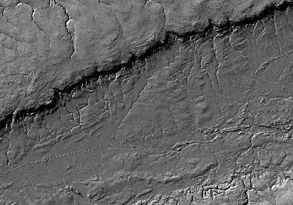
Shaded Relief Image of the North Mountain Area, Nova Scotia
DP ME 455, Version 1, 2010. Shaded Relief Image Derived From a 5 m LiDAR Bare-Earth Digital Elevation Model of the North Mountain Area, Digby, Annapolis and Kings Counties, Nova Scotia
Related Products
... DP ME 438
Abstract
This shaded relief image is derived from a LiDAR bare-earth DEM gridded at 2m cell size from a composite of several individual surveys dating back to 2000. The 2 m cells were resampled to a 5 m grid that the shaded relief image was constructed from. The shading azimuth was 315 with a 45 elevation angle. No vertical exaggeration has been applied. The original DEM processing and creation of the shaded relief image was done by Tim Webster at the Applied Geomatics Research Group (AGRG) and supplied to MRB in an ESRI geodatabase raster format. This image was used by Dan Kontak to assist in the mapping of the North Mountain Basalt flows and the creation of MRB digital product DP ME 438 and Open File Maps 2010-7 to 2010-12. The shaded relief image reveals details of the morphology of the bedrock and surficial materials. The different North Mountain basalt flow units have variable resistance to erosion with the Middle Flow Unit (MFU) being much weaker than the Lower Flow Unit (LFU) and Upper Flow Unit (UFU). The differing erosion rates shows up on the shaded relief image and allows the flows to be mapped more accurately.
Disclaimer
The DATA is provided to the USER on an "as is" basis, without warranties of any kind, express or implied.
The entire risk as to the quality and accuracy of the DATA is with the USER and the USER shall use his/her own judgment in making use of the DATA or drawing conclusions based upon it.
NR&R shall not be liable to the USER, his/her clients, servants, agents, contractors, assigns, or to any other person for any loss or damage of any kind including personal injury or death arising from the use of the DATA or accompanying written materials, or from errors, deficiencies or faults therein, whether such damage is caused by negligence or otherwise. If errors or omissions are found in the DATA, the USER will notify NR&R.
The terms and conditions of the license accompany the downloaded digital product.
Format
ArcInfo File Geodatabase (GDB), JPEG Image (JPG) and TXT files compressed in self-extracting EXE/ZIP files (more information on data formats)
Size
GDB - 134 MB (compressed), 135 MB (uncompressed)
JPG - 24.5 MB (compressed), 25 MB (uncompressed)
Projection
The data is in six-degree Universal Transverse Mercator (UTM) projection, Zone 20, Central Meridian 63° 00' West using the North American Datum of 1983 (NAD83).
Downloading Instructions
The data files have been compressed using PKZIP into a single, self-extracting EXE file.
- Read the Licence before accepting the data.
- Download the self-extracting EXE file to the desired location on your hard drive.
- Double click or "RUN" the EXE file and the data files will be unzipped automatically.
The EXE file can also be opened in WinZip to view and extract the compressed files in the data set.
On UNIX platforms, the unzip command will extract the compressed files in the EXE.
All data sets are in six-degree Universal Transverse Mercator (UTM) Zone 20 projection using the NAD83 datum.
A readme file and a copy of the licence agreement are also included with each data set.