
Vista 1: Squally Point
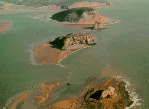
We are flying over scenic Five Islands, named after the five offshore islands, Moose, Diamond, Long, Egg and Pinnacle. How did these island form? Glooscap (Deity of the Mik'maq, in a fit of rage, threw giant handfuls of sod at Beaver, his nemesis, for mocking his magical powers. Each of these sods is now one of the islands.
Conventional interpretation: Five Islands are the eroded remnants of a basalt cuesta formed by synclinal folding of a basalt-capped sedimentary sequence. The islands are laterally displaced from the Cape Split southward-plunging syncline through strike-slip translation along the Cobequid Fault.
Summary for non-geologists: The town of Five Islands rests on a flat plain, which was formerly a delta where powerful streams flowed into the ocean from a glacier situated in the hills behind the town. About 14,000 years ago the land was pushed down due to the great weight of glaciers, and sea level was ~15 m higher than the land. The ocean in contact with the glaciers at that time was called the DeGeer Sea. After retreat of the glaciers the land popped up rapidly, and today the delta surface (where sea-level once stood) is high and dry with many camper trailers on it.
Those in cars. Leave the Debert site and get back on the Trans-Canada Highway going west. Take the exit to Great Village-Bass River-Parrsboro. Travel west along Highway 2 approximately 70 km to Five Islands. (See map).
Description
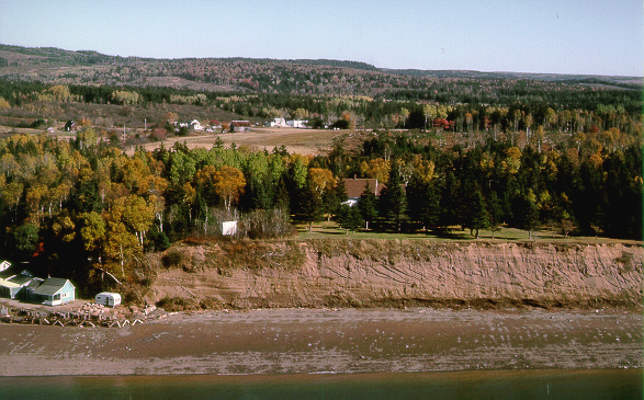
Terraced outwash delta deposits are found at the mouths most major rivers that flow southward into the Minas Basin. The delta at Lower Five Islands has a tripartite structure with well-defined topset, foreset and bottomset beds classified as a Gilbert-type delta. You can see the three clear divisions of the delta above. Swift and Borns (1967) named these outwash gravel deposits the Five Islands Formation and divided them into two members, the upper (topset) glaciofluvial Saints Rest Member and a lower (foreset and bottomset) glaciomarine Advocate Harbour Member. The upper surface of the delta at Lower Five Islands slopes seaward approximately 6.5 m/km.
The topset beds of the Saints Rest Member average about 3.5 m thick and are a coarse gravelly sand, with massive to crude horizontal bedding, and discontinuous lenses of medium sand. Cut and fill channels are common. The uppermost facies is rich in Cobequid Highland igneous and metamorphic erratics derived from the uplands to the north. Below this is a unit characterized by cobbles and boulders of red sandstone. The Advocate Harbour Member foreset beds dip 20-30 degrees to the southeast at the distal point and are separated from the topset beds by a planar angular unconformity. The beds vary in texture from ice proximal gravelly sand to medium to coarse sand. The contact with the topset beds is about 15 m above mean sea level. The bottomset beds of the Advocate Harbour Member are made up of rhythmites characterized by 1 to 2 cm thick, red sandy clay beds interbedded with 2-3 cm thick sand beds.
Interpretation
The horizontal topset beds of the delta at Five Islands are braided stream (gravel bar and channel) deposits formed by rapid deposition from meltwater streams emanating from a glacier. The foreset and bottomset beds are interpreted as the proximal and distal parts of the prograding slip-face of the glaciomarine delta. The maximum elevation of the topset/foreset unconformity (15 m) represents relative sea level at the time. The relationships of ice contact stratified drift in the river valleys to the north and the outwash deltas suggest that an ice margin existed there and it receded northward. Delta slopes and paleocurrent indicators show that glacier meltwater streams were largely confined to the valleys and flowed southward. Recession of the ice margin across varying rock formations is responsible for variations in the pebble lithology of topset units. Look at a map of the former glaciers!
Some Useful References
- Stea, R. R., Finck, P. W. and Wightman, D. M.1986:
- Quaternary geology and till geochemistry of the western part of Cumberland County, Nova Scotia (sheet 9); Geological Survey of Canada, Paper 85-17, 58 p.
- Swift, D. J. P. and Borns, H. W., Jr 1967:
- A raised fluviomarine outwash terrace, north shore of the Minas Basin, Nova Scotia; Journal of Geology, v. 75, no. 6, p. 693-710.
- Wightman, D. M. 1980:
- Late Pleistocene glaciofluvial and glaciomarine sediments on the north side of the Minas Basin, Nova Scotia; Ph. D. thesis, Dalhousie University, Halifax, Nova Scotia; Nova Scotia Department of Mines and Energy, Thesis 405, 426 p.
Go back to the chopper (virtual field trip home page) or