
Stop 8: The Joggins Section: An Unparalleled Record of Shifting Glaciers in the Maritime Provinces
Oh yeah … and some pretty neat fossils too!
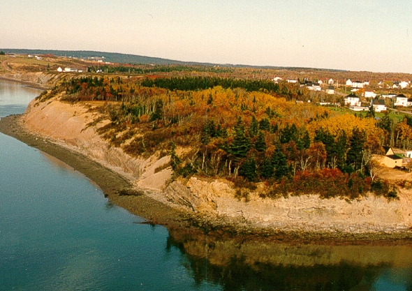
The chopper is approaching McCarron Brook and the village of Joggins is in sight! You can see the till section where we're going to land in the distance. Joggins is a coal mining town dating back to the 1600s, but now is more famous for its fossil cliffs, which include the earliest land snails and first reptiles. But (at least to me) its glacial geology is even more interesting!
Go to the Nova Scotia Museum to learn about the wonderful Carboniferous history and fossils of Joggins!
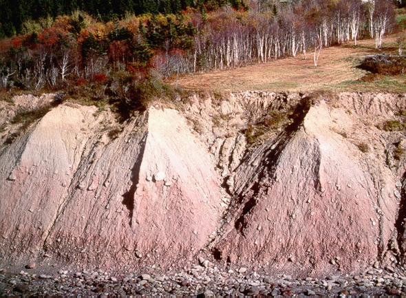
Summary for non-geologists: The Joggins section reveals three layers of glacial deposits, each with a different colour. The colour differences are a result of shifting glacier centres in the Maritime Provinces during the last ice age. The lowest and oldest glacial layer is a reddish, muddy till (mixture of mud and gravel transported and deposited underneath the glacier) formed when a huge ice sheet from New Brunswick or Quebec crossed the Bay of Fundy and scooped up the red rocks under the bay. The middle grey till formed when a smaller glacier centred around Prince Edward Island flowed into the Bay of Fundy to the southwest, and scooped up coal and grey Carboniferous rocks that underlie the town of Joggins. Finally, the upper yellow till formed when a Nova Scotia-based glacier flowed north into the Northumberland Strait.
Description
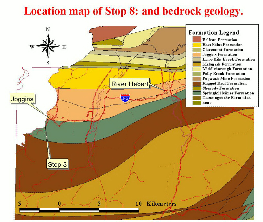
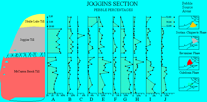
Wickenden (1941) and Prest and others (1972) have previously described the Joggins section, noting its distinctly reddish, grey and yellowish tills, which we can see out the chopper window. Let's land! As we move up for a closer look, we can see that the lowest reddish till has a high percentage of rocks not found locally. A plot of the pebble types in the section from top to bottom illustrates the vertical variation and lithological signature of each of these till units. The base of the McCarron Brook Till (lowest till) has the highest percentage of igneous and volcanic erratics (far-travelled rock) and purple argillite derived from the Caledonia Highlands to the west (Pebble types G and I). There are simultaneous increases in the percentages of calcareous red mudstone (Pebble Type H) and limestone (Pebble Type F) clasts upsection. The grey Joggins Till has distinctly higher percentages of coal and limestone pebbles (Pebble Types B and C) than the McCarron Brook Till. The ice flow direction inferred from this change in composition is southwestward, across the Joggins Formation (see map 400 kb), which outcrops along the shore to the northeast of the section. (R. J. Ryan, personal communication, 2000). The upper Shulie Lake Till can be distinguished from the lower two units by the preponderance of local feldspathic sandstone and sideritic concretions and sandstone (Pebble Types J and D) which give the till a distinctive yellow colour. In earlier publications I had interpreted the flow direction of the upper till as southwestward, similar to the Joggins Till (see references below),largely based on a strong southwest till fabric. New bedrock mapping since the publication of those results, however, suggests that the source of the abundant sideritic concretions and grey sandstone is the Springhill Mines Formation (see map 400 kb), outcropping under the section and to the south and southeast, implying a northeastward ice flow. The southwest fabric in the Shulie Lake Till is likely due to a late southwest flow directed into Chignecto Bay that may have reset the clast fabric.
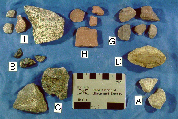
Rock types in the Joggins section. (Key to pebble type diagram) (A) grey sandstone, (B) coal, (C) limestone, (D) sideritic concretions, (G) brown-purple argillite, (H) calcareous red sandstone, and (I) metamorphic and igneous rocks.
The McCarron Brook Till overlies bedrock inscribed with glacial striae trending 110° and younger striae trending 235-250° especially near the contact with the Joggins Till. "Bullet" boulders near the contact also display a southwest orientation and striae pattern. This section provides ample evidence for reworking and deformable tills under ice sheets. Till fabric and composition in the upper part of the McCarron Brook Till have been altered by the ice flow depositing the Joggins Till. At the top of the McCarron Brook Till is a zone of weathered joints, fractures and manganese oxide staining suggestive of alteration by soil processes, perhaps representing a brief period of ice retreat between glaciations.
Interpretation
The Joggins till section records the clockwise shifting of ice flow centres across the Maritimes during the Wisconsinan. During the Early Wisconsinan (75-49 ka) Caledonia Phase (New Brunswick/Laurentide?) ice flowed eastward and southeastward depositing the McCarron Brook Till. During the Late Wisconsinan (21 ka) Escuminac Phase, a large ice sheet developed over Prince Edward Island, and flowed into the Bay of Fundy forming the Joggins Till. Finally, in the last stages of glaciation, ice flow shifted north and then back to the southwest during the Scotian and Chignecto Phases, forming and reworking the Shulie Lake Till.
Some Useful References
- Prest, V. K., Grant, D. R., MacNeill, R. H., Brooks, I. A., Borns, H. W., Ogden, J. G., III, Jones, J. F., Lin, C. L., Hennigar, T. W. and Parsons, M. L. 1972:
- Quaternary geology, geomorphology and hydrogeology of the Atlantic Provinces; 24th International Geological Congress, Excursion Guidebook, A61-C61, 79 p.
- Stea, R. R., Finck, P. W. and Wightman, D. M. 1986:
- Quaternary geology and till geochemistry of the western part of Cumberland County, Nova Scotia (sheet 9); Geological Survey of Canada, Paper 85-17, 58 p.
- Wickenden, R. T. D. 1941:
- Glacial deposits of part of northern Nova Scotia; Transactions of the Royal Society of Canada, Section iv, p. 143-149.
Go back to the chopper (virtual field trip home page) or