
Stop 16: Collins Pond Section: Type Section for Younger Dryas Glaciation in Eastern Canada
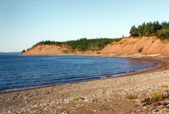
The Collins Pond site is located 25 km northeast of Guysborough, along the north shore of Chedabucto Bay. We have landed the chopper in front of two southeastward-trending drumlins along the actively eroding shore. Waves have sliced through the drumlins creating 25 m thick sections. In 1986, along the flanks of each of the drumlins, we discovered a thin, continuous peat and wood horizon sandwiched between two tills. The peat layers were dated from 12.1 to 10.9 ka (~14-12.9 CAL) so the overlying till is Younger Dryas in age, a time of rapidly cooling climates in the hinterlands bordering the North Atlantic, and possibly worldwide. The explanation for this abrupt change in climates during a regime of global warming is still being debated.
Summary for non-geologists: At this site we will see peat and wood buried by glacial till, evidence of an advance of glaciers at the end of the last ice age. The cool period is known as the Younger Dryas (named for an arctic flower whose pollen appears in lake core records from northeastern Europe) and during that time glaciers advanced in many parts of the Earth. In Nova Scotia this event is well recorded because glaciers had not entirely retreated from the region and when the climate cooled again glaciers were able to advance and form deposits. A similar record of climate change during this interval is not found in central Canada, probably because of lack of proximity to the north Atlantic which serves to moderate our climate today, but may have been the engine of climate cooling in the not so distant past.
Description
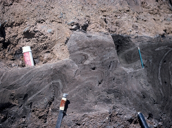
The drumlins are cored with a greyish-red, matrix-supported, silty diamicton (Unit I) interpreted as till. Embedded diorite pebbles in Unit I are derived from the Antigonish Highlands to the northwest and west. Overlying Unit I on the side of one drumlin is a sequence of 10 cm of organic silt and clay, 40 cm of fibrous peat with small twigs, and 10 cm of grey clay with thin organic layers. The organic bed thins abruptly to the west against the steep flank of the drumlin. This intermittent, thin bed of matted peat can be traced up the eastward-dipping Unit I surface until it pinches out near the drumlin crest. At the same stratigraphic level farther east along the drumlin a brown silty sand is intercalated with the organic seam. Unit II, a stony, matrix-supported diamicton overlies the organic layer and Unit I. Thin seams of sand and organic clay occur within Unit II. Pebble fabric in Unit II is strong and trends southwestward with an eastward plunge, indicating southwestward ice flow.
On the eastern flank of the adjacent drumlin another buried organic layer was found in 1989, consisting of overturned and recumbently folded peat and sandy peat layers overlying a gravelly sand bed and till. The folds were attenuated to kinked vertical layers at the base of the peat block. The structural style of this peat bed is complex. A fold near the top of the peat trends 245 degrees, verging to the northwest. The axial plane is oriented southwest-northeast and is nearly horizontal, parallel with the upper diamicton contact. Long axes of wood fragments in the peat block parallel the southwest clast fabric in till Unit II. The radiocarbon age of the base of the organic unit in the eastern section is 12.1 ka and the youngest is 10.9 ka, falling within the Allerød/Younger Dryas Chronozones.
Palynology
The pollen profile of the thick peat bed in the eastern section shows that Cyperaceae (sedge) increases to a maximum in the middle of the peat along with Pteridophyta (fern and fern allies) spores. At this level the peak is almost completely Equisetum (horsetail). Near the top of the peat, Salix (willow) values exceed 50%, and Cyperaceae levels are much lower. Betula percentages increase and Salix declines in the overlying organic clay. The pollen assemblage in the narrow organic bed exposed beneath till Unit II differs from the thick peat profile because of lower Salix and Cyperaceae levels and higher Betula, Pteridophyta, and Polypodiaceae (fern)levels. Betula level succeed those of Salix in the thin peat horizon of section A. Tree pollen levels are low and uniform in all peat layers sampled.
Interpretation
Two major, early ice flow events are recorded by striations, erratic dispersal, till fabric and drumlin orientation in the Guysborough area. The first major ice flow was southeastward and southward, followed by northward flow from the Scotian Ice Divide, which was offshore on the continental shelf south of the Canso Peninsula. Ice then retreated prior to 12.1 ka (~14 CAL) allowing vegetation to migrate into the area. Shallow ponds and sedge meadows occupied low wet areas. Tundra-like shrub communities of willow and possibly some birch surrounded the wetlands and occupied the lower slopes. Sparse herbaceous vegetation occupied open areas on the slopes and dominated the uplands. No trees were present. These conditions remained unchanged, except for increasing shrub birch representation at the expense of willow, until 10.9 ka (~12.9 CAL).
Diamictons overlying the peat deposits could have two possible origins:
- Solifluction or gelifluction flows and
- Till.
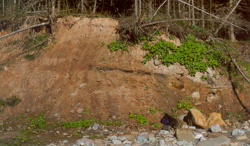
Earth and debris flows are poorly sorted, locally derived, and have parallel clast orientations, similar to till. Long axis orientations in laboratory-simulated flow deposits tend to be highly variable with strong transverse fabrics are also possible, especially at the toe of a flow. The fabric in Unit II, however, is very consistent along the section, with a trend at variance to slope. The lack of morphological evidence for a flow, such as a headwall scarp, a toe bulge, or parallel strips, also mitigates against a flow hypothesis. Sheet gelifluction processes in subarctic climates produce asymmetrical drumlins which are not apparent here. Till Unit II has a planar contact with lower units on the drumlin flank, and increases in thickness upslope in a regular manner to a maximum of 8 m. A symmetrical precursor drumlin underlies the peat section and till Unit II. The intense, mylonitic deformation of the peat bed is unlikely to have been produced by solifluction.
The discovery of several more buried Allerød organic paleosols along the Sable Island gas pipeline route and in southwest Cape Breton have further advanced our knowledge of Younger Dryas glacier limits. Look at a map that shows the proposed maximum extent of ice advance during the Younger Dryas glaciation. Red dots are sites with the Allerød soil buried by glacial lake sediment and triangles are till-covered sites. Blue shading represents the extent of ice marginal lakes, and the outlets are shown with blue arrows.
Some Useful References
- Mott, R. J., and Stea, R. R.1994:
- Late-glacial (Allerød/Younger Dryas) buried organic deposits, Nova Scotia, Canada; Quaternary Science Reviews, v. 12, p. 645-657.
- Stea, R. R., Forbes, D. L. and Mott, R. J.1992:
- Quaternary Geology and Coastal Evolution of Nova Scotia; Geological Association of Canada, Mineralogical Association of Canada, Joint Annual Meeting, Wolfville '92, Field Excursion A-6, Guidebook, 125 p.
- Stea R. R., and Mott, R. J. 1989:
- Deglaciation environments and evidence for glaciers of Younger Dryas age in Nova Scotia, Canada; Boreas, v. 18, p. 169-187.
- Stea R. R., and Mott, R. J.1998:
- Deglaciation of Nova Scotia; Stratigraphy and chronology of lake sediment cores and buried organic sections; Géographie physique et Quaternaire, v. 41, p. 279-290.
Go back to the chopper (virtual field trip home page) or