
Vista 2: Eskers of Southwestern Nova Scotia
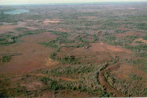
We are flying over a long esker system southeast of Fifth Lake Flowage and west of Kejimkujik Lake (see stop map). An esker is a sinuous ridge made up of sand and gravel, formed in a meltwater tunnel under a glacier. Can you spot the ridge snaking across the landscape? These were called "Indian Ridges" by early European settlers of North America who thought they were man-made. These ridges trend eastward, indicating a flow of water from a glacier sitting over Kejimkujik Lake at the end of the last glaciation (see Story of Glaciers in Maritime Canada).
As we zoom in for a closer look, the ridge clearly stands out against the boggy areas beside it. There is a parallel gravel ridge probably representing the confluence of a couple of subglacial tunnels under the former ice cap. This ridge might be a good place to have a bite to eat. A little wine and smoked salmon perhaps?
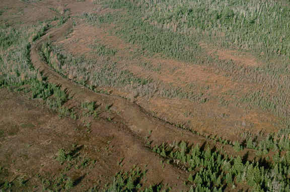
We're almost ready to land and the ridge is clearly seen. There is a path along the esker, used not by people, but by the local moose and deer populations. It is obviously much easier to walk along the esker (a glacially constructed natural road) than through the surrounding bogs.
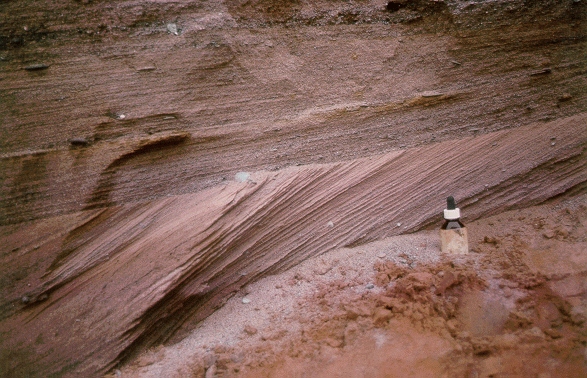
While we're having lunch I will dig up a bit of the ridge with my plastic lunch spoon to look at it's internal makeup. What we see inside the esker is sand and gravel sorted by the action of fast-flowing glacier meltwater. The dip of mega-ripple cross-beds tells us the meltwater flow direction. In this case towards the east. Glacier hydraulics are controlled by the thickness and temperature of glaciers. As you might expect, these eskers formed during the melting stages of glaciation between 13 and 15 thousand (radiocarbon) years ago.
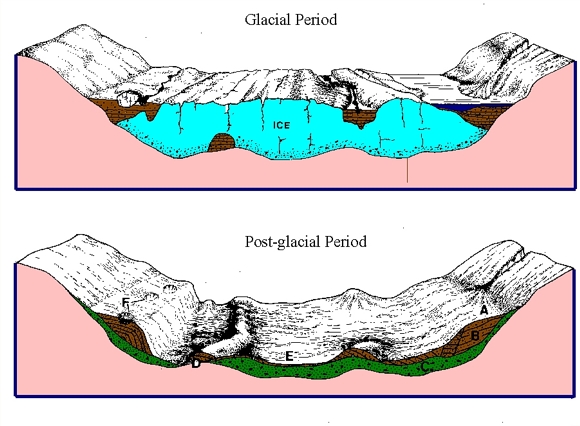
Above is a cartoon explaining the formation of eskers and other glacial landforms. A valley glacier collects material from rivers of glacial meltwater on top of the ice, adjacent to the glacier, and in tunnels underneath the ice. Sometimes ephemeral lakes form between the valley glacier and the surrounding hillsides. This would be a the case in the Parrsboro and Margaree valleys of Nova Scotia, for example. Toilet-bowel like depressions called "moulins" form on top of the glacier, where meltwater funnels down to the base of the ice. When the ice melts, waterlain material (sand and gravel) deposited in the lakes beside the ice and later slumped down on the valley sides are called kame terraces (B). Material melted out underneath the ice is called glacial till (C). Sinuous ridges of gravel and sand (eskers) form in tunnels under the ice (D). Hills of gravel and sand formed when the toilet bowls (moulins) melt are called "kames" (E). Circular holes in the kame terraces form when ice blocks left in the sediment melt. These are called "kettles" (F).
Let's get Go back to the chopper (virtual field trip home page) or
Look at the Parrsboro outwash delta and glaciated valley: Vista of the Month 3.