
About Karst Risk Map
View Basic Interactive Karst Risk Map
(Link to User Guide)
View Advanced Interactive Karst Risk Map
Open File Report ME 2019-001 - A Karst Risk Map of Nova Scotia
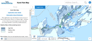
This application was developed to show areas of Nova Scotia where there is a relative high-, medium- or low-risk of encountering karst and naturally occurring sinkholes caused by soluble bedrock.
Sinkhole development in karst terrain can cause extensive damage to buildings, roads and other infrastructure. The primary geohazard in karst areas is sudden catastrophic subsidence due to the collapse of cavities in the bedrock created by the dissolution of soluble evaporite or carbonate rocks. Caution should be exercised in potential karst areas when constructing buildings or roads.
The risk zones are based on several factors, including geology, sinkhole locations and professional judgement. The high-risk zone contains 96% of the sinkholes in the Nova Scotia Sinkhole Database and has densities of greater than 1 sinkhole per 100 km2.This zone includes the Windsor Group, a 500 m buffer zone around the Windsor Group which contains abundant sinkholes, and the George River Metamorphic Suite. The medium-risk zone contains 3.9% of the sinkholes in the Nova Scotia Sinkhole Database and has densities between 0.1 and 1 sinkholes per 100 km2. This zone includes the Horton and Mabou Groups. The low-risk zone contains less than 0.1% of the sinkholes in the Nova Scotia Sinkhole Database. This zone typically does not contain sinkholes or karst topography. However, sinkholes may still occur in this area due to unmapped soluble rocks (i.e. evaporites or carbonates) or where soluble rocks are close to the ground surface but overlain by other rock types or unconsolidated material.
For more information about sinkholes in Nova Scotia, please visit: https://novascotia.ca/natr/meb/hazard-assessment/sinkholes.asp
RELATEd PRODUCTS