
Stop 11: West Lawrencetown Drumlin Section: Type Section for Late Wisconsinan till on the Atlantic Coast

East of Halifax lies the Chezzetcook Drumlin Field where many streamlined drumlins create an undulating topography resembling a pod of whales surfacing on the ocean. Out of the chopper window we can see a couple of drumlins near West Lawrencetown ripped open by the relentless attack of North Atlantic waves. Even from this vantage point you can see two tills, grey at the bottom and red on top. This is perhaps the most important section of Pleistocene deposits in the Halifax area. Let's land and check it out!
Summary for non-geologists: The West Lawrencetown drumlin reveals three till deposits, masses of boulders and clay, formed by glaciers that flowed across the Halifax region between 70,000 and 11,000 years ago. The drumlin has been shaped by glaciers during these separate advances into a lobate form, with one lobe parallel to an early southeastward ice flow from a New Brunswick glacier and another aligned with a later southward flow from an ice cap over the Gulf of St. Lawrence. A rock outcrop next to the drumlin shows crossing scratches or striae made by these glaciers as they scoured the exposed bedrock. The till deposits contain erratic boulders that have undergone a lengthy journey from their home outcrops in the Cobequid Highlands, 100 km to the north, carried by fast-moving rivers of ice called ice streams.
Description
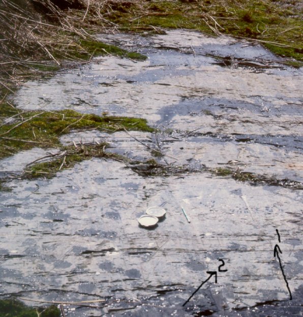
A striated outcrop beside the drumlin shows two directions of flow: 1-southeastward, 2-southward. Note the well-developed nailhead striae parallel to striae 1.
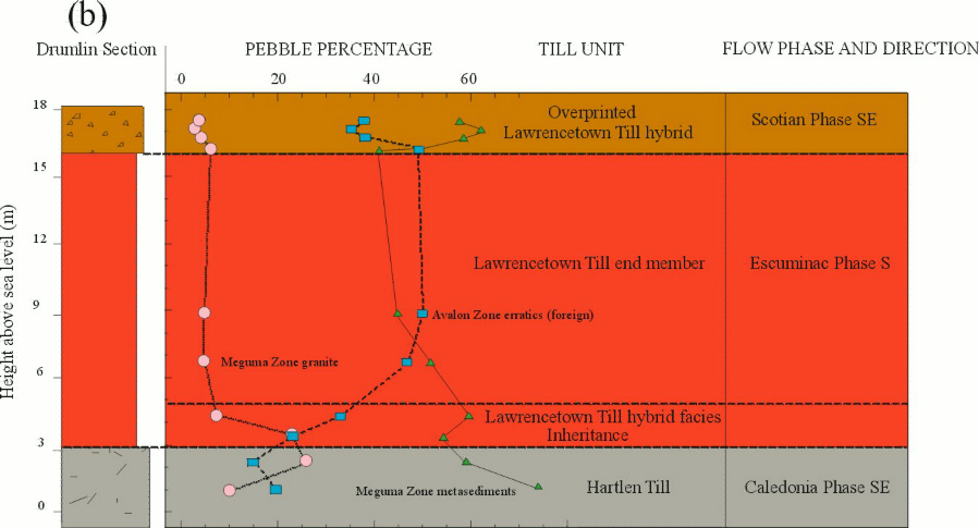
The West Lawrencetown section was first described by Doug Grant (1963) and later by Eric Nielsen (1976). The drumlin has a v-shaped, lobate form with a main axis trending 150° and another axis trending 185°. Look at a detailed drawing and map of the section. Between the two lobes is a circular depression, partially eroded by the sea, with a base resting on a lower till unit. This depression was interpreted as a kettle by Grant (1963). Two exposures separated by the inter-lobe depression reveal two compositionally-distinct till units, the Hartlen and Lawrencetown Tills.
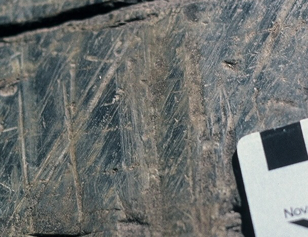
Bedrock outcrop on the western flank of the drumlin complex reveals wide, parallel grooves 10-40 cm in width, and striae that trend 155° cut by another distinct set of slightly divergent, finer striae trending 180°-190°. See a close-up of the two striae sets. Notice that the fine striae skip across down-glacier facing sides of grooves formed during the earlier movement, and are best developed on the up-glacier facing part of the groove. The relative ages are determined not by cross-cutting relationships, which can be ambiguous, but by the upper surface development of the finer southward-trending striae.
Stratigraphy
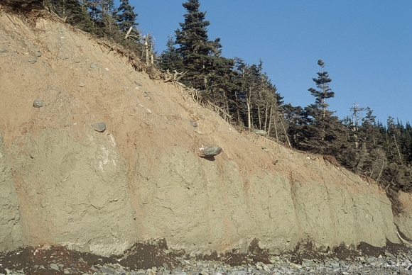
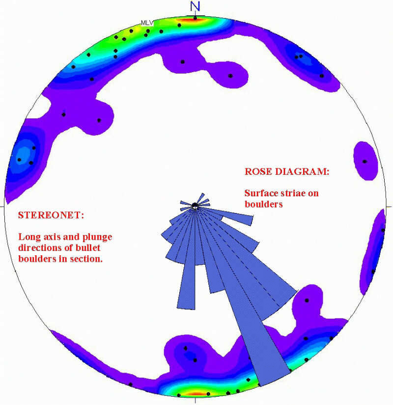
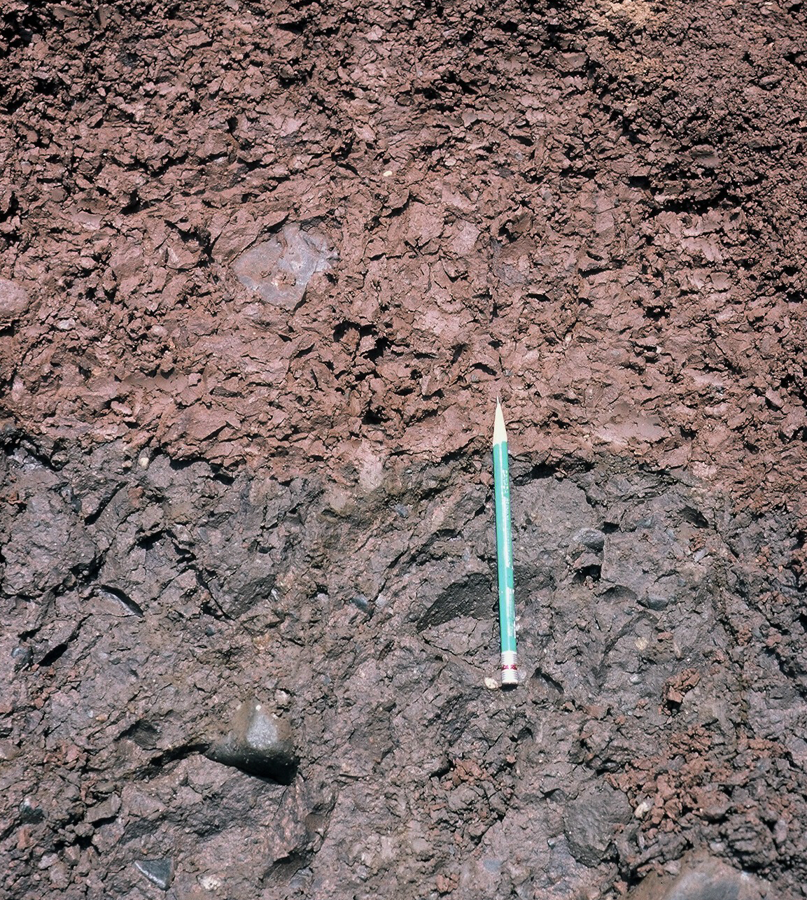
The lower Hartlen Till (seen above) is grey, matrix-supported and compacted. Bullet stoss-lee boulders embedded in the Hartlen Till and at the Hartlen-Lawrencetown till contact (see above) trend parallel to the major drumlin axis. Till fabric in the Hartlen Till trends parallel to the main drumlin axis and the oldest bedrock striae set. Pebble counts (>1000) in the Hartlen Till average 59% metagreywacke (derived from of the underlying Cambro-Ordovician Meguma Group), 23% whitish, megacrystic Meguma Zone granitic pebbles, and 17% foreign (non-Meguma Zone) pebbles. Foreign lithologies include North Mountain basalt, red and grey siliclastic rocks, pink alkali-feldspar granitoids, diorite and felsic and mafic volcanic rocks.
A distinctly reddish, muddy, matrix-supported till (Lawrencetown Till) overlies the Hartlen Till with a knife-sharp contact. The Lawrencetown Till can be divided into an upper, sandy facies and a lower, clay-rich facies with sand inclusions. The lower facies exhibits a southward-trending till fabric, parallel to the lobate drumlin axis and the youngest striae set on the adjacent bedrock outcrop (see above). Bullet-boulder long axes, and striae on the upper surface of these boulders, reflect the imposition of a southward ice flow. The upper facies of the Lawrencetown Till has a till fabric that trends southeastward, subparallel to the Hartlen Till, and it is enriched in local Meguma Zone pebbles. This till fabric was probably reset during the penultimate SE ice flow from a divide over Nova Scotia which also overprinted the Lawrencetown till with a flux of local bedrock (Scotian Phase-Stea et al., 1998).
Pebble counts in the lower clay-rich facies of the Lawrencetown Till (>1000) average 49% metagreywacke, 46% erratics, and 3% Meguma Zone granite, but local metawacke clasts increase to 70% in the upper hybrid facies. Foreign pebbles in the Lawrencetown Till include, in order of abundance, salmon-pink, hornblende-bearing granite, granodiorite, diorite, and mafic and felsic volcanics.
Interpretation
Source of drumlin erratics and ice stream tills
Eastern Grenville Province erratics including high-grade metamorphic rocks (granulite and migmatitic gneisses) and plutonic rocks (anorthosite and charnockite) have not been identified at this section or anywhere else in Nova Scotia. A Canadian Shield source and by implication a Laurentide-based ice flow is unlikely. All erratics at this section have been demonstrated to have Maritime Appalachian bedrock sources. North Mountain basalt erratics are found exclusively in the Hartlen Till and suggest a southeastward flow from known outcrops along the Bay of Fundy. The Lawrencetown Till contains distinctive pink granite erratics with sodic amphibole that are derived from the Hart Lake-Byers Lake pluton near the Debert River in the eastern Cobequid Highlands, and porphyritic rhyolite that is probably derived from the adjacent rocks to the northeast (Stea and Pe-Piper, 1999). Granite with sodic amphibole is restricted to an area of a few square kilometres around the Debert River, and all the other erratic pebbles from the section have a source outcrop within a few kilometres of this amphibole-bearing granite. This narrow range of source lithologies defined as a "provenance envelope" clearly delineates a southward ice flow.
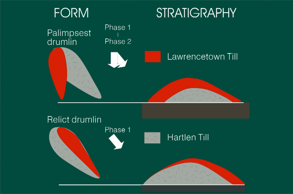
The drumlin "core" till (Hartlen Till) is derived from a flow across the Bay of Fundy termed the Caledonia Phase (Rampton et al. 1984; Stea et al., 1998). This till is interpreted as a lodgment facies (Nielsen, 1976; Podolak and Shilts 1976), with boulder pavements and sand inclusions near the contact with the Lawrencetown Till suggesting a thin englacial-meltout till facies neat the top of the till unit.
The drumlin "mantle" till (Lawrencetown Till) at both drumlin sections records a distinct southward shift in ice flow direction to an ice divide over the Magdalen Shelf, underlain by Carboniferous red-beds (Escuminac Ice Divide). A much more extensive southward Laurentide ice flow from Quebec (Acadian Bay Ice Lobe-Goldthwait, 1924) can be ruled out because of the absence of Canadian Shield erratics and striae that indicate a radiating ice flow from the Gulf of St. Lawrence. The Lawrencetown Till has an unusually high and consistent erratic (non-Meguma Zone) content (>50%), with only minor dilution by local rocks along flow-lines (Finck and Stea, 1995). This is a strong indication of fast-moving ice streams, under extending flow, characterized by the lack of mixing between the englacial and basal glacier zones (Clark, 1987). In fact, Grant (1963) hypothesized that all drumlins in Nova Scotia were formed as a result of warm-based, rapid ice stream flow, because the surrounding regions are characterized by locally derived, stony tills, presumably bypassed by the fast moving ice. Nielsen (1976) interpreted the Lawrencetown Till as a basal melt-out till based on the abundance of sand inclusions and long-distance transport.
Growth of shelf-based ice domes
Arguments for rapid accretion of shelf-based ice domes were first summarized in Denton and Hughes (1981). The provenance data compiled in this paper support the hypothesis of Late Wisconsinan shelf-based glacier growth on the Magdalen Shelf. The formation of calving bays in the deep marine channels that bisected Maritime Canada during the Mid-Wisconsinan may have isolated an ice mass centred over the Magdalen Shelf plateau. This remnant ice mass, plugging drainage divides in the surrounding uplands, rapidly accreted during the Late Wisconsinan aided by diversion of the jet stream and increased snowfall around the larger Laurentide Ice Sheet. Ice streams draining the Escuminac Ice Divide were funnelled into channels between morainal banks on the outer Scotian Shelf and calved into the open ocean at the edge of the continental shelf (Mosher et al., 1989).
Drumlins and catastrophic floods
Shaw and Sharpe (1987) have proposed that catastrophic subglacial meltwater outbursts can form drumlins, both by erosion and deposition. This intriguing theory can be tested with data from Nova Scotia. Drumlins described in this study, and elsewhere in Nova Scotia, are largely made up of till and are surrounded by ice-scoured bedrock, inscribed with two or more sets of crossing striae. How do multiple striation sets form after a late subglacial outburst that presumably eroded the till-dominated drumlins and adjacent bedrock? Drumlin trends are strongly correlative with striae trends in Nova Scotia (Stea and Brown, 1989), and many drumlins were formed by local ice caps. These residual ice masses would be unlikely candidates for the huge meltwater reservoirs envisioned for a regional subglacial flood. The lack of a widespread cover of gravel and sand and absence of unequivocal meltwater erosional forms, such as gravel-filled potholes, all mitigate against a catastrophic outburst.
Time-independent process models have dominated much of the previous thinking on drumlins and other glacial landforms. The complex geomorphic effects produced by the multiple glaciations of the Laurentide and Scandinavian ice sheets have been documented by Veillette (et al., 1999) and Kleman (1994). The West Lawrencetown drumlin is considered to be a palimpsest landform, that has evolved over two or more glacier flow phases.
Some Useful References
- Clark, C. D. 1993:
- Mega-scale glacial lineations and cross-cutting ice-flow landforms; Earth Science Processes and Landforms, v. 18, p. 1-29.
- Finck, P. W. and Stea, R. R. 1995:
- The compositional development of tills overlying the South Mountain Batholith; Nova Scotia Department of Natural Resources, Mines and Minerals Branch, Paper 95-1, 51 p.
- Goldthwait, J. W. 1924:
- Physiography of Nova Scotia; Geological Survey of Canada, Memoir 140; p. 60-103.
- Grant, D. R. 1963:
- Pebble lithology of the tills of southeast Nova Scotia; M. Sc. Thesis, Dalhousie University, Halifax, Nova Scotia, Canada, 235 p.
- Kleman, J. 1994:
- Preservation of landforms under ice sheets and ice caps; Geomorphology, v. 9, p. 19-32.
- Nielsen, E. 1976:
- The composition and origin of Wisconsinan tills in mainland Nova Scotia; Ph. D. Thesis, Dalhousie University, Halifax, Nova Scotia, Canada, 256 p.
- Podolak, W. E. and Shilts, W. W. 1977:
- Some physical and chemical properties of till derived from the Meguma Group, southeast Nova Scotia; in Geological Survey of Canada, Report of Activities, Part A, Paper 78-1A, p. 459-464.
- Prest, V. K., 1983:
- Canada's heritage of glacial features; Geological Survey of Canada, Miscellaneous Report 28, 89 p.
- Rampton, V. N., Gauthier, R. C., Thibault, J. and Seaman, A. A. 1984:
- Quaternary geology of New Brunswick; Geological Survey of Canada, Memoir 416, 77 p.
- Shaw, J. and Sharpe, D. R. 1987:
- Drumlin formation by subglacial meltwater erosion; Canadian Journal of Earth Sciences, v. 24, p. 2316-2322.
- Stea, R.R. and Pe-Piper, G., 1999:
- Using whole-rock geochemistry to locate the source of igneous erratics from drumlins on the Atlantic coast of Nova Scotia; Boreas, v. 28, p. 308-325.
- Stea, R. R.,1994:
- Relict and palimpsest glacial landforms in Nova Scotia, Canada; in W. P. Warren and D. G. Groot, eds., Formation and Deformation of Glacial Deposits; Balkema, Rotterdam, p. 141-158.
- Veillette, J. J., Dyke, A. S. and Roy, M., 1999:
- Ice flow evolution of the Labrador sector of the Laurentide ice sheet: a review, with new evidence from northern Quebec; Quaternary Science Reviews, v. 18, p. 993-1019.
Go back to the chopper (virtual field trip home page) or