
Stop 10: Gibraltar Rock: Spillway for Glacial Lake Shubenacadie
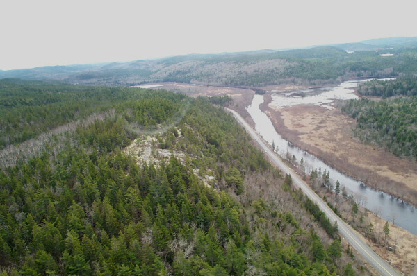
Gibraltar Rock is a granite peak that commands a view of the mighty Musquodoboit River. After winding its way westward through the lowlands to the north, the Musquodoboit River then takes a sharp southward turn and cuts through a gorge cut into solid granite. The highlands to the south are the Atlantic Uplands, an exhumed upland surface underlain by Cambro-Ordovician slate and metawacke, and Devono-Carboniferous granite. An ancient peneplane slopes from 300 m elevation in the vicinity of Gibraltar Rock to sea-level along the Atlantic coast. Look at the stop map. During this stop we will discuss the origin of the misfit valley, and the evolution of the local landscapes.
Summary for non-geologists: The Musquodoboit River cuts through a gorge at Gibraltar Rock that was formed by the drainage of a large glacial lake, which filled most of the Musquodoboit Valley. Receding glaciers at the end of the last ice age created a huge ice dam in the Minas Basin, blocking the natural northward drainage through the Shubenacadie River system. When the Minas Basin was plugged by a large glacier, glacier meltwater and streams had nowhere to go and filled up the Shubenacadie and Musquodoboit valleys. Like a huge bathtub, they filled and overflowed. This overflow route was through the Gibraltar Rock gorge.
Description
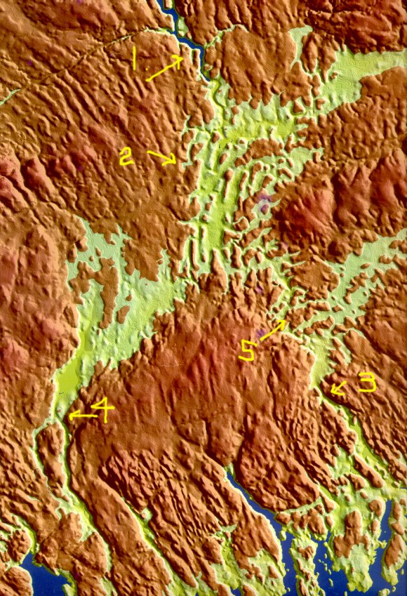
Digital terrain model of central Nova Scotia courtesy of Tim Webster, College of Geographic Sciences, Lawrencetown.
Much of central Nova Scotia is drained today through the Shubenacadie River system (see 1 above) which runs 86 km from the head of Grand Lake into the Minas Basin. At the end of the last ice age between 10 and 12 ka (11.5-14 CAL) glaciers twice blocked the Shubenacadie River outlets and the lakes that formed in the Shubenacadie and Musquodoboit valleys have been named Glacial Lake Shubenacadie 1 and 2.
Clay deposits occur sporadically throughout the valleys, deposited during these glacial lake phases. One outlet was through a chain of lakes in Dartmouth, Nova Scotia, that end up in Halifax Harbour (see 4 above). Another outlet was through the Gibraltar gorge, and the Musquodoboit River (see 3 above). The digital elevation model (DEM) the regions under 30 m elevation in green, and these represent the known levels of Glacial Lake Shubenacadie based in strandlines and clay deposits. It is clear from the DEM that if the Shubenacadie Valley was blocked, the Musquodoboit Valley would have also filled with water if it was ice free.
Interpretation
Goldthwait (1924) proposed that the Musquodoboit River below Gibraltar Rock follows an old southeastward course, an ancient drainage pattern established prior to glaciation and later reoccupied as moraines or drift covered the divide. Lin (1971) came essentially to the same conclusion. Roland (1982) argued that the Musquodoboit River was a tributary of a north-flowing Cretaceous system basing his ideas on the assumption that Cretaceous clay found in the valleys formed after the valleys were first excavated by erosion. According to this reasoning the valleys formed in the Early Cretaceous or Late Jurassic. Seismic and drillhole data however, imply that the erosional model is erroneous, because the lowland Cretaceous deposits were down-faulted in the Middle Cretaceous and the ancient structural valleys were exhumed from under a thick cover of Mesozoic and Cenozoic sediments.
Goldthwait was partially correct in his assertion that the Musquodoboit River may have re-occupied an old southeastward-river system, but the evidence of an extensive morainal dam in the lowlands to the north is lacking. There are some ablation till deposits in the vicinity of the river, but the hills that cut off the two valley systems to the northeast (see 5 top figure) are rock-cored rather than made up of glacial deposits. It is more likely that the gorge was cut by successive glacial lakes dammed up in the Musquodoboit Valley releasing torrents of meltwater through the relatively narrow outlet at Gibraltar. These lakes formed not only at the end of the last glaciation, but prior to the glaciation as well, as ice sheets built up in northern Nova Scotia. Evidence of the clay deposits of pre-Wisconsinan glacial lakes can be found in drillholes and seismic profiles of the Musquodoboit Valley.
Some Useful References
- Goldthwait, J. W. 1924:
- Physiography of Nova Scotia; Geological Survey of Canada, Memoir 140, p. 60-103.
- Lin, C. L. 1971:
- Cretaceous deposits in the Musquodoboit river valley; Canadian Journal of Earth Sciences, v. 8, p. 1152-1154.
- Roland, A. E. 1982:
- Geological Background and Physiography of Nova Scotia; Nova Scotian Institute of Science publication, Ford Publishing Co., Halifax, 311 p.
- Stea, R. R. 1998:
- Surficial geology of the Shubenacadie area [11E/03], Colchester, Halifax and Hants Counties, Nova Scotia; Nova Scotia Department of Natural Resources Open File Map ME 1998-3, Scale: 1:50 000.