
Stop 15: Moose Point Section: Interglacial Rise and Fall of Sea Level
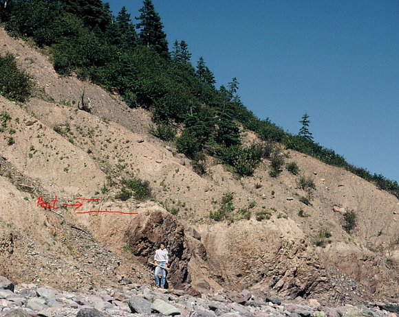
Sections along the north shore of Chedabucto Bay reveal seven lithostratigraphic units lying above an erosional platform cut into rock. What is most intriguing about this section is a peat bed with large spruce wood fragments. The bed lies directly on the wave-cut bench and predates the deposition of tills. If the rock platform represents a former high stand of sea level that predates glaciation (see Stop 13) then the peat layer with wood, represents a drop in sea-level, perhaps during the onset of glaciation. A similar section is found at Long Point, Cape Breton Island where marine sand overlies the peat.
Summary for non-geologists: The Chedabucto Bay coast has some spectacular examples of barrier beaches, derived from the erosion of drumlin headlands, in which Moose Point is one example. The sea has exposed the geological record of the last 130,000 years, starting with an ancient shore platform when sea levels were 4-6 m higher during the last interglacial warm period 128-115 ka. At the end of the interglacial period climates began to cool and the forests changed from mixed deciduous to coniferous-boreal type similar to northern Quebec today. As the climate cooled to ice age conditions, the formation of huge glaciers over North America caused sea levels to drop, and a forest was established where the sea once was. Then, after the onset of glaciation, the glaciers advanced over the Chedabucto Bay area several times, depositing mud sand and boulders, first moving toward the east, and then to the northwest.
Description
The oldest surficial unit in sections along Chedabucto Bay is silty sand containing compressed peat layers with large wood fragments (Unit 1). This lies directly on weathered regolith of the shore platform cut into siltstone 4-6 m above tide level. Spruce wood from the compressed peat produced a radiocarbon date of >49 000 yr B. P.(GSC-4419 HP).
Above the peat layer and platform is an indurated, matrix-supported, silty diamicton (Unit 2), forming the core of many of the drumlins. The presence of distinctive appinite (mafic pegmatite) boulders in the unit implies an ice flow either towards the east or southeast from two of the only known stocks of this distinctive rock (J. B. Murphy, personal communication, 1990). Ice flow across the stock north of Antigonish is consistent with the modal trend of long axes of the till-embedded (bullet) boulders found in Unit II (115-125 degrees). Shell fragments in Unit 2 are presumably derived from St. Georges Bay.
Units III and IV are waterlain units, consisting of fairly continuous, horizontally stratified gravelly sand and silty sand beds.
Unit V is a diamicton distinguished from Unit II by greater stone content. This unit contains till-embedded boulders that indicate a northwestward ice flow, parallel to the ice flow indicated by regional trends of glacial striae.
Palynology
Preliminary pollen analysis of the organic unit shows pollen spectra near the base with abundant Picea (spruce) and Pinus (mainly P. banksiana/resinosa type) (jack/red pine) pollen and small values for other taxa. As Picea declines and Pinus increases slightly above the base of the profile, Polypodiaceae (fern) spores become extremely abundant. Pinus reaches a maximum in mid-profile and then declines as Picea continues to decline and Polypodiaceae returns to low values. At the top of the profile, Alnus (alder) species dominate, Picea and Pinus have low levels, and herbaceous taxa levels increase.
Interpretation
The peat deposits indicate that northern, boreal-type coniferous forest of spruce and some jack pine occupied the area at time of deposition. Ferns were abundant, at least locally, for part of the time. Willow, grasses and herbs inhabited open areas. Increasing alder and herbs and declining spruce and pine probably indicate a cooling trend prior to the onset of glaciation. The waning phase of a warm interval such as Marine Oxygen Isotope Substage 5e is possible, but it may also relate to a younger, cooler interval such as Substage 5a when sea-levels were substantially lower than present.
Units II and V are interpreted as till because of their massive and indurated nature, erratic content, and the abundance of stoss-lee boulders parallel to underlying bedrock striations indicating subglacial lodgment. The ice flow associated with Unit II is eastward and southeastward termed the Caledonia Phase. Unit V was deposited during the development of the Scotian Ice Divide, which is offshore on the continental shelf south of the Canso Peninsula.
Some Useful References
- Stea, R. R., Forbes, D. L. and Mott, R. J. 1992:
- Quaternary Geology and Coastal Evolution of Nova Scotia; Geological Association of Canada, Mineralogical Association of Canada, Joint Annual Meeting, Wolfville '92, Field Excursion A-6, Guidebook, 125 p.
- Stea, R. R., Mott, R. J., Belknap, D. F. and Radtke, U. 1992:
- The pre-Late Wisconsinan Chronology of Nova Scotia, Canada; in P. U. Clark and P. D. Lea, eds., The Last Interglaciation/Glaciation Transition in North America; Geological Society of America, Special Paper 270, p. 185-206.
Go back to the chopper (virtual field trip home page) or